Thursday, 28 October 2010

Hongje and Gireum: On the hunt for retaining walls

Up towards the Apatu

Hongje and Gireum are two areas in the north of Seoul where buildings are eroding the landscape, literally building into the slopes of the mountains. This, of course, isn’t out of the ordinary in Seoul. As demand for more space continues to the rises, the more demand there is to build. As my sketches from ‘Sketching Through the Haze from Namsan Mountain’ (211010) observed, the city is gradually weaving its way around the mountains. However when outward sprawl is exhausted, upwards sprawl offers an alternative. This is now reality in Seoul.

The point where city meets landscape is changing. Putting aside, for a moment, the moral question of corrosive expansion, it is important to understand how this edge condition is currently being dealt with. After Ryul’s tip off and a wander round two such areas in Seoul, the answer is retaining wall, after retaining wall. 
1 Retaining curved 2 End of the street 3 Steps up and up
As I reached street level from Hongjie station below, the view revealed the topography immediately. Mountains loom in the background behind proud Apatu apartments with shops and cafes in front. Alleyways lead off the main street rising up along steep slopes with low rise housing to either side. At the end, looking up, a giant Apatu rises from the ground utterly out of scale from anything that exists (apart from the mountains perhaps). What ensures it doesn’t tumble down the street? A hefty concrete retaining wall which residents of the older building have to look out on to. An unsightly necessity?

Heyri Artists Village

All references from Germany-Korea Public Space Forum: Heyri Art Valley: The Emergence of an Architectural Guideline, Kim Jong Kyu

Prior to Heyri, recent urban planning in Korea consisted of a simple formulaic sequence. This began by selecting an area, then establishing zoning laws divided according to function, and finally building a structure. Towards the mid-nineties though, the public started voicing the their opposition to these government-controlled developments. Instead, they called for ‘the need to create communities which supported a common purpose and vision among residents’. So, Heyri became reality.

Heyri is an artists village which includes houses, cafes, galleries. For the project, an architectural guideline was devised which allowed architects designing individual buildings enough freedom to be creative whilst maintaining a coherent composition over the whole site - ‘an urban contextual framework that can accommodate and anticipate the condition of unpredictable expansion and growth’. The relationship to, and integration of, the landscape was a priority from the start. For example, placing the artificial elements (i.e. buildings) only in areas which are appropriate to the landscape thereby retaining a certain amount of natural space. Two types of public space are repeated across the site; ‘untouched natural areas, and ‘artificial plates’. The latter provides spaces which future buildings can be built on.
From Germany-Korea Public Space Forum
L-r: Patch / Bar-type - follows topographical flow of site, Gate House - includes residential-block concept, Stepped patch / Podium type - slope means buildings must be elevated on podium or plinth to retain horizontal continuity (retaining wall unavoidable), Plate / Object-type - provided where it is not suitable to define area

In plan, a poetic description resembling an open hand is convincing. The topography of mountains and valleys determines how the buildings are located and orientated; the properties are mainly located on flatter parts, six hills envelop the site and the waterway connects with the swamp.

Upon arrival, crossing a bridge under which the natural landscape has been preserved was a good start. Looking past, the whole area felt more natural, and less ghostly, than Paju Book City. There were cyclists searching maps, children laughing and stylish arty-types sipping coffee.
My memories of the varying landscape surfaces - car parking / gravel, natural, untended, overgrown

However, with my eye fixed predominantly on the relationship to the landscape, I felt a little perplexed. Besides the mature natural areas mostly around the stream, are gravel squares – presumably car parks, buildings overgrown with weeds, and untended grass patches. Rather than feeling natural, some parts felt uncared for, unfinished, left over. Indeed, it was the architectural intention to allow space for future buildings but a village shouldn’t feel like it’s waiting for more, with something missing, should it? Perhaps the planned ‘natural’ areas between buildings need to be treated as artificial entities – we plan them, so we need to take care of them?

Referring back to the article:

            ‘A proper balance between the natural and artificial topography was paramount. Surface covering was reduced to a minimum, with artificial elements used to give order to areas without visually dominating them’.

The principles seem correct, as we should treat new villages nestled in Korea’s mountainous landscape. Heyri responds to the topography but the edge condition – between the artificial and the landscape – requires, in my opinion, more attention than simply leaving it to nature.

Abandoned building overgrown


Car park, gravel surface

Edge condition - between natural and artificial

Wednesday, 27 October 2010

Positive Thinking Publishing House (2007) and YoulHwaDang Book Hall (2003, 2009) Florian Beigel and ARU London, Choi JongHoon + NIA Seoul

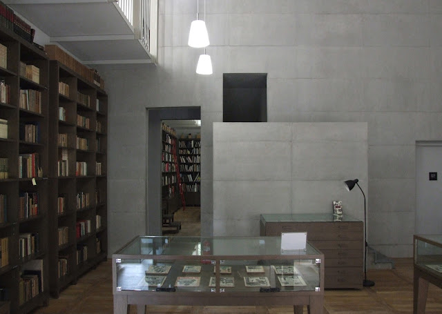
Library, YoulHwaDang Book Hall (vc)

From The ARU website, the architects describe Paju Book City and their buildings in it in relation to landscape:

We think the building should tell a story about the place and the landscape in which it is situated. The urban design of Paju Book City is shaped by the existing landscape: the views of the mountain, the large Han River and the mountain ranges beyond the river, and most importantly by the 10m high flood protection dam of the freedom highway and by the wetland territories in Paju. In the design for Postive Thinking building one finds these landscape imprints, particularly in the stepping forms of the buildings.’

On the approach to Beigel’s building ‘ensemble’, something different begins to unfold along the street. The two grey brick buildings – Positive Thinking Publishing House – sit on an angle to one another allowing space for a small public area between which opens up towards the street. Past the second brick building, a set back courtyard-like space leads up to the entrance of YoulHwaDang. One side of this space is a tall black timber clad wall which reaches out to the edge of the pavement. Past this, a pale concrete façade is revealed stepping back from the street edge again, allowing space for the largest public area in front of the building (see diagrams below).

Sketch collage diagrams: public space between, public space in front, street approach (vc)

As Alpa mentioned, walking around the interior of YoulHwaDang felt like were were inside one of Beigel’s drawings. Beautifully finished interiors create clean, sharp spaces that manage to retain a scale, and materiality, of domesticity. This was something Beigel’s clients had told him they enjoyed in the workplace.

A small entrance hall leads onto a bookshop to the left and concrete stairs lead to office spaces above. To the right, a small corridor leads to the later addition of the building, also the most homely part. The kitchen is crisp and cool but the bottle of Listerene on the table is just one of many signs of life. The building isn’t too pristine to touch. It feels lived in. The final two rooms make up the library. It feels almost like a modest religious space; double-height, chapel-like with a mezzanine level, floor to ceiling timber shelves and low hung lighting. The closest experience prior to this visit would have to be the library in the Glasgow School of Art.

The employees we spoke to know Beigel and appreciate the effort he and ARU went to create such a space to work in. It feels to me that this building works on two levels. On a theoretical architectural level of exploring landspace in the city, and also on a very human level, the employees simply enjoy being there.

Tuesday, 26 October 2010

Visit: Paju Book City

The concept of an industrial city exclusively for books sounded odd to me, and that feeling lingered as we arrived at the side of a main carriage-way, what seemed like a lot of unfinished public space and some interesting-looking buildings.

Paju Book City promotes itself as a place which is ‘fundamentally different from the past practice of making cities fill space’. Nestled amongst the Hangang’s wetlands and Simhak mountain it is described by Yi Ki-ung (Chairman of Bookcity Culture Foundation) as a place in harmony with nature, of humanistic qualities, which aims to restore a common value. He blames the loss of a collective attitude on Korea’s modern history; Japanese rule, the Korean War, authoritarian rule, and an influx of Western culture on Korean society.
Mapping Paju Book City
Left - right: Looking across reed stream to Simhak mountain, Figure ground, Reed stream, 'Green' space, Road (vc)
All maps show outline of mountain edge to west

The surrounding make their impression and the reed stream running through the city shapes the layout to the north end of the city (see plan). However, the integration of landscape within the city – between buildings for example – lacks the presence that I had expected, and hoped for. The ‘green spaces’ as shown on the map tend to be gravel car parks or untended planted areas. Of course, ‘landscape’ is described very differently by architects, including Beigel where he describes his ensemble of buildings at Paju as landscape themselves (see post).

Sunday, 24 October 2010

Crit 1: introduction to project intentions

Pin up
Guest tutors: Jonghwan Ahn, Jieun Lee, Christian Schweitzer, Haewon Shin, Ryul Song

This was the first opportunity to introduce our projects to tutors at KNUA, and visiting critics. General feedback raised the question specificity. At this stage, I found difficult to answer. What is landscape? I must question and define what landscape means to me and what my parameters are.

211010 Crit comments - overview

Jon Wan: Look at Yong San Park
- Competition held to design a new park in Seoul on an old army base
- This project lies somewhere between landscape and architecture

What is ‘landscape’?
- Best to refer to ‘landscape’ only, define what landscape means to me (definition should be in contract)

Landscape in the city fabric
- Look at landscape at various scales, not just mountains but plants climbing walls etc. (small study)

Mountains appear from a distance to be in control but actually much is controlled by people/city e.g. hiking, satellites, etc.
- how does Seoul’s landscape impact on culture here?

Subsequent chat with Professor JK
- pointed me to Beigel’s writing and works and how we organise landscape. I have begun reading some of Beigel’s writings so will continue down this route of research and visit Paju Book City
- there are differences between nature and landscape, this landscape is how the city is organised within the landscape – research direction

Landscape and city evolving


2010 Seoul today


‘600 Year’s Maps of Seoul’ splits Korean history into chapters – Age of the Joseon Dynasty, Age of Japanese Rule and Age of Republic of Korea – documenting the development of the city through maps. The mountains are included from the earliest maps to the most contemporary, more evidence of their significance in the city.
1750 Map of Walled Capital; Seoul. Manuscript in colour


1939 New Map of Great Seoul


1973 Map of Seoul


From Kim Seon-ah’s article ‘Nature Inverted’:

          ‘To this day, Seoul remains tied to its natural characteristics, surrounded by the elements. The relationship between its orography and urbanisation is fundamentally important…
          Seoul was originally built within the bosom of nature, encompassed by mountains on several sides. The principles of urban formation always ordered the city to form a special bond with natural elements, and all the demands found their answers in selected regions. This gave the city a positive and dynamic force, but the growth of the city eventually began to consume nature. As construction boomed and spaces entered into increasing relationships with urbanised natural spaces with the city, the expanded city started to occupy natural spaces… In the end, nature is engulfed in the city, it belongs to it, collaborates in urban functions, relinquishes its autonomy and its specific identity, sustains development and does not shy away from the exploitation of its image and its significant value. It is considered an element of urbanisation.’

This excerpt speaks less of the dominance of the landscape and more of the city claiming the landscape as part of its urban fabric. The relationship is often described as one sided, but what is in control; the city or the landscape? Perhaps rather than approaching this subject as ‘either or’ it should be more about how each can enhance the other. Are we too greedy in our want to be close to the landscape? Should the city stop infringing, stop its sprawl and begin somewhere else?

It will be useful to visit Paju Book city and Heyri Art Village, two new ‘settlements’ stepping out of the city and beginning afresh. This somehow seems unnatural, surely cities should grow naturally developing as needs change – but when do we stop?

Thursday, 21 October 2010

Sketching through the haze from the Namsan Mountain

When exploring the orography of a city, climbing the Namsan Mountain is a must. Leaving the city suspended in a cable car and seeing the tops of high-rise apartment blocks at eye level offers a very different perspective. No longer dwarfed by the dense ‘Trump towers’, the domination of Seoul’s mountains is truly realised.

Beyond the ‘lovers locks’, revolving restaurant and teddy bear museum are some of the best views of the city. The Namsan is one of the more modest mountains in Seoul reaching only 237.6 meters in height, but its location in the middle of the city sets it aside from the peripheral mountains. The hazy day meant views weren’t the clearest but at least this meant there was some relief from the hundreds tourists who flock to this popular spot.

Sprawling cities spilling into the landscape and around the mountains seems almost infinite. As nightfall came, Seoul lit up boasting at least five giant television screens in each direction. Hundreds of snaking headlights crawling towards the Hangang and out of the centre as commuters made their way home weaving around the mountains.
Top left-right: Eroding the landscape, Through and beyond, To the Hangang, Tall buildings
Bottom left-right: Along the horizon, Another tower, Up to the summit, Light in the dark


My sketches are an attempt to draw simply what I saw, without preconceived ideas of how the city should move around the mountains. On reflection though, it seems the city is eroding the landscape but can it only eat away at it so far?

An excerpt from ‘Nature Inverted’ by Kim Seon-ah:

‘Colossal elements [of the landscape] remain unchanged, suffering no damage. [Human intervention] is no more than a scrap on the surface. Rather than conquer it, the city works its way around the obstacle, surrounds it and moves on.’

Tuesday, 19 October 2010

Gyeongbokgung

View from Gyeongbokgung roofs to mountains

With mountains to the north, a traditional Korean residential neighborhood to the West and city to the East and South, Gyeongbokgung is in the heart of Seoul, at a juxtaposition between old and new. A tourist spot? Yes, but what interests me most about this palace is understanding how Seoul began, the processional layout of the palace buildings and its grounds, and its relationship to the mountains beyond.

Several important observations:

- Views (framed) from city to mountains: Korean architecture prioritises the relationship between (and views to) architecture and landscape. There is also a similarity between the roof scape and landscape - purposeful or coincidental?
- Traditional Korean building systems and materials – 'Ondol' (under floor heating) provides warmth through raised floors; an ancient tradition. Also traditional, is the use of paper on walls and windows and the consequent effect on lighting
- Light conditions in Seoul seems different from other places. What may partly explain this is that in October, Seoul has an average of eight hours sunlight a day. Comparatively, London has just three hours during the same month. Undisputedly, this will have an impact on the use of natural light saving electricity and effective use of thermal mass.
- Colour and decoration: brightly painted facades and decorative patterns

Architecture referencing landscape


Colour, decoration and paper

Saturday, 16 October 2010

Seoul, we've arrived

From The River Han to the mountains


We've arrived. We rented bicycles yesterday and cycled along The River Han. It seems that every sight, in almost every direction seems to be framed by a mountain on the horizon. The subject of mountains is an important thread which may lead the project over the next few weeks. How has the city grown around the mountains?

Wednesday, 6 October 2010

Samsung Museum of Art

http://leeum.samsungfoundation.org/eng/architecture/building02.asp


The Leeum, Samsung Museum of Art is situated on the Namsan Museum. The museum website describes the MUSEUM 2 building, designed by Jean Nouvel, as a building which 'integrates itself into the natural landscape while remaining an autonomous contemporary art object in its own right'. It responds to context without disappearing into the landscape. The colour of the facade subtly picks up the tones of the roof of the older building beyond. It will be interesting to see if the building works as well in reality as it appears to in this photograph.

Sunday, 3 October 2010

Satellite photo of North and South Korea by night

Satellite photo - Nothing to Envy, page 03


'North Korea faded to black in the early 1990s. With the collapse of the Soviet Union, which had propped up its Communist ally with cheap fuel oil, North Korea's creakily inefficient economy collapsed. Power stations rusted into ruin. The lights went out.' (Nothing To Envy, page 03)
This revealing satellite image starkly contrasts the bright lights of Seoul (South Korea's capital) to the black mass of North Korea. The only glimmer of light in the North is Pyongyang, the capital. Its population of 23 million people are almost completely hidden from view.